Photo Documentary – The Karakoram Highway to Pakistan

At the base in Tarim Basin, Danxia Landformations reveal its red rocks.

Oasis’ can be found along the Karakoram Highway (although not at higher altitudes), where vegetation allows for small villages to harvest food

A man preparing his house for the winter, in the Tajikh Autonomous Region in the south west of Xinjiang.

Lakes of melting water are formed at high altitudes (4000M+), as the soil is incapable of retaining the water, deserts like sceneries emerge on mountain tops.

Muztagh Ata, or Muztagata is the second highest (7546 metres) of the mountains which form the northern edge of the Tibetan Plateau.

At the Sino-Pakistani border, military posts of both nations guard the gates and tresspassing seems impossible
The long road to the Khunjerab Pass along the Karakoram Highway (more…)
Couples #2

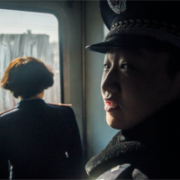
Which direction is the man facing? Towards or away from the camera….

Although not entirely blacked out, the soft bokeh creates a sharp fine line across this lovely girl’s face. (Wo Ai Ni Jing!)